
23 nightsFrom San Antonio, Chile11 ports of call
Valparaiso to Papeete
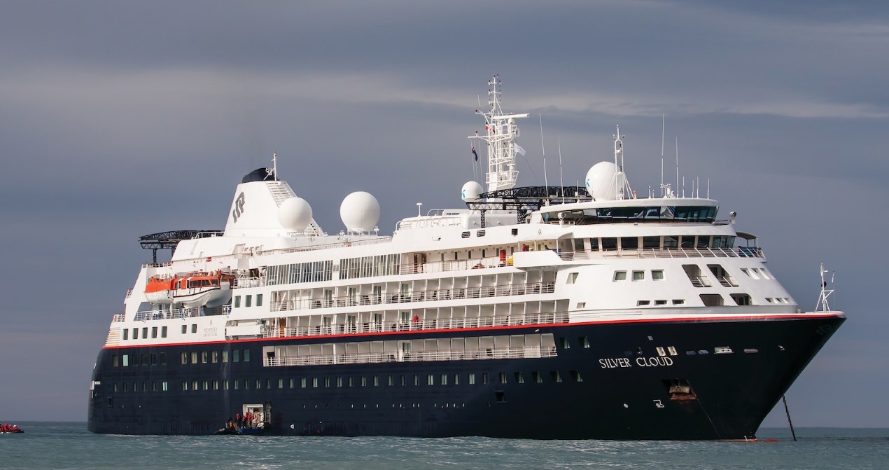
Silversea · Silver Cloud
Overview
A 23-night voyage aboard Silver Cloud, departing San Antonio, Chile on 11 Mar 2028 and arriving in Papeete, calling at 11 destinations along the way.
San Antonio, ChileRobinson Crueso IslandAlexander Selkirk Island, ChileEaster IslandAdamstown, Pitcairn IslandsRikitea, Mangareva Island, Gambier IslandsHanavave (Fatu Hiva)Tahuata, Marquesas IslandsFakarava, Tuamotu IslandsMooreaPapeete
Cabin prices
Live prices per person based on two sharing. Select a grade to see its fare options.
Loading live cabin prices…
Itinerary
23 nights · 24 ports of call- 2
Day 2 ·Santiago (Valparaiso), ChileEmbark
11 Mar 2028Arrive 19:00Depart 20:00Embark the Prince Albert II and depart on your exciting 11-day Silversea Expedition – “Chilean Fjords Highlights”. This evening, you will be introduced to your Expedition Leaders. - 2
Day 2 ·At Sea
12 Mar 2028 - 4
Day 4 ·Robinson Crusoe Island
13 Mar 2028Arrive 18:30Depart 19:00The friendly English-speaking population offers a unique blend of African, Spanish, Paya Indian and British cultures. British and Spanish settlers invaded the Paya as their respective countries fought over possession of Roatan in the 16th century. Soon after, pirates numbering nearly 5,000, including Henry Morgan, claimed Roatan as their stronghold. During the height of the slave trade, Roatan became a dumping ground for rebellious slaves that the British could no longer control. These marooned slaves, now called Maroons or Garifuna, form a present day ethnic group near the town of Punta Gorda. This unique mix of people and cultures, presently controlled by Honduras, has created a population that is rich in tradition yet welcoming to visitors. - 5
Day 5 ·Alexander Selkirk Island, Chile
14 Mar 2028Arrive 17:00Depart 17:30Think of Daniel Defoe’s classic novel Robinson Crusoe and you will be picturing an intrepid castaway, marooned on a paradisiacal island. That image might be ideal for movie lovers, but the actual inspiration for Robinson Crusoe was a salty Scottish seadog who went by the name of Alexander Selkirk. Selkirk was marooned in Chile’s Juan Fernandez archipelago for four years and four months, rescued by a British private warship. Despite Selkirk’s slightly chequered past, he was greeted as a celebrity upon his return to England.
His adventures were given a gloss and immortalised in the much loved 18th century classic. Alejandro Selkirk Island is located 165 kilometres west of the other islands in the archipelago, for a surface area of just under 50 m2. The island was renamed from its Spanish name Isla Más Afuera in 1966 by the Chilean government in homage to the sailor. The topography is very different form the Caribbean dream that Defoe writes about, think dense woodland, rugged coast and peaks, shrouded (more often than not) in cloud. Sandy beaches can be found to the north of the island. Throughout much of its history, the island has been uninhabited, although there is a former penal settlement on the middle of the east coast, which operated from 1909 to 1930. During the summer months, Selkirk welcomes a small community of lobster fishermen and their families who come from Robinson Crusoe. As part of the Chilean National Park, it also holds the UNESCO World Biosphere Reserve title. - 5
Day 5 ·At Sea
15 Mar 2028 - 6
Day 6 ·At Sea
16 Mar 2028 - 7
Day 7 ·At Sea
17 Mar 2028 - 8
Day 8 ·At Sea
18 Mar 2028 - 9
Day 9 ·Easter Island, Chile
19 Mar 2028Easter Island, the easternmost settled island of Polynesia, received its European name in 1722 when the island was seen by a Dutch expedition under Roggeveen on Easter Sunday. The triangular-shaped island of 163 square kilometers is famous for the hundreds of statues known locally as moai. Rolling hills covered in grassland, eucalyptus forest and a rocky shore surround Hangaroa, the island’s only village on the southwestern coast.
This is where Captain Cook landed in 1774, where missionaries built the first church and where ships find the best protection from winds and swells. Small beaches and transparent waters invite swimmers and snorkelers, but it is the cultural aspect which attracts visitors. Since 1935 the island has been a National Historic Monument and today 43.5% of the island is a national park administered by the Chilean National Forest Corporation and Mau Henua, a local community group. The island’s national park has been declared a UNESCO World Heritage Site in 1995. Found slightly more than 3,500 kilometers west of Chile, the island was annexed in 1888. Used as a sheep ranch for many decades, the island was opened in 1965 and an airstrip was built. The US Air Force set up a base to record the behavior of the earth's outer atmosphere and by 1987 NASA had the runway extended as an emergency runway for the space shuttle. This never happened, but tourism benefitted from this improvement and today the island receives more than 100,000 visitors a year. - 11
Day 11 ·Easter Island, Chile
20 Mar 2028Arrive 17:30Depart 18:00Easter Island, the easternmost settled island of Polynesia, received its European name in 1722 when the island was seen by a Dutch expedition under Roggeveen on Easter Sunday. The triangular-shaped island of 163 square kilometers is famous for the hundreds of statues known locally as moai. Rolling hills covered in grassland, eucalyptus forest and a rocky shore surround Hangaroa, the island’s only village on the southwestern coast.
This is where Captain Cook landed in 1774, where missionaries built the first church and where ships find the best protection from winds and swells. Small beaches and transparent waters invite swimmers and snorkelers, but it is the cultural aspect which attracts visitors. Since 1935 the island has been a National Historic Monument and today 43.5% of the island is a national park administered by the Chilean National Forest Corporation and Mau Henua, a local community group. The island’s national park has been declared a UNESCO World Heritage Site in 1995. Found slightly more than 3,500 kilometers west of Chile, the island was annexed in 1888. Used as a sheep ranch for many decades, the island was opened in 1965 and an airstrip was built. The US Air Force set up a base to record the behavior of the earth's outer atmosphere and by 1987 NASA had the runway extended as an emergency runway for the space shuttle. This never happened, but tourism benefitted from this improvement and today the island receives more than 100,000 visitors a year. - 11
Day 11 ·At Sea
21 Mar 2028 - 12
Day 12 ·At Sea
22 Mar 2028 - 13
Day 13 ·At Sea
23 Mar 2028 - 15
Day 15 ·Adamstown (Pitcairn Island)
24 Mar 2028Arrive 19:00Depart 19:30Home to the original mutineers of the Bounty, Adamstown’s is today the capital of all four Pitcairn Islands. The islands – the last British Overseas Territory in the Pacific – include the namesake Pitcairn Island itself, plus the uninhabited Oeno, Henderson and Ducie. Pitcairn is the archipelago’s only inhabited island, with the population of just 50 centred in Adamstown.
It is no surprise that the nine mutineers along with six Tahitian men, 12 Tahitian women and one child stopped on Pitcairn in 1790; with its sloped and varied landscape, lush tropical promise and equidistant location between Peru and New Zealand, Pitcairn would have seemed an ideal hiding spot for the mutineers to settle. The ship was burnt to avoid detection (the ballast stone remains of the wreck in Bounty Bay). However, the ideal bucolic life that mutineer leader Fletcher Christian had envisaged was not to be. Poor treatment of the Tahitian men led to alcoholism, chaos and carnage and by 1800 only John Adams – who had recently discovered Christianity – remained. Adams taught the women and children to read and write from the bible. The capital is named after him. Not only had the island been misplaced on early maps of the region, but it can also be very difficult to come ashore as large breakers tend to build up just in front of the small harbour of Bounty Bay. The local museum houses the HMS Bounty Bible, the same bible that Adams taught the women and children to read and write from in the early 19th century. - 15
Day 15 ·At Sea
25 Mar 2028 - 17
Day 17 ·Mangareva (Gambier Islands)
26 Mar 2028Arrive 18:30Depart 19:00In the Gambier Islands of French Polynesia, Mangareva is the largest island with a population of over 1,200 people. Most live in Rikitea, the largest village on the island. A high central ridge runs the length of Mangareva peaking with Mt. Duff, which rises over 440 meters from the sea on the island's south coast. The island has a large lagoon sprinkled with coral reefs whose tropical fish and the black-lip oysters have helped islanders survive much more successfully than on other nearby islands. View less
Small ships are able to enter the lagoon of Mangareva. Ashore visitors can walk through the town, see the remains of the massive stone and coral buildings dating back to the 19th century or climb up Mt. Duff. The highlights in town include the cathedral with its mother-of-pearl shell altar and objects designed and built in the 1830s and 1840s and partially restored by the students of Rikitea’s school just a few years ago. - 17
Day 17 ·At Sea
27 Mar 2028 - 18
Day 18 ·At Sea
28 Mar 2028 - 20
Day 20 ·Hanavave, Fatu Hiva
29 Mar 2028Arrive 18:30Depart 19:00 - 21
Day 21 ·Tahuata, Marquesas Islands
30 Mar 2028Arrive 14:00Depart 14:30 - 21
Day 21 ·At Sea
31 Mar 2028 - 23
Day 23 ·Fakarava, Tuamotu Archipelago
1 Apr 2028Arrive 17:30Depart 18:00Fakarava is oblong shaped and has an almost continuous string of reef and motu stretching for 40 km (25 mi) on its eastern edge. It's the second largest of the Tuamotu atolls, located 450 km (280 mi) northeast of Tahiti, and 120 km (75 mi) southeast of Rangiroa. It's renowned for the drift diving in its two passes—Garuae (also spelled Ngarue) in the north near the main town of Rotoava (and the airport) and Tamakohua Pass, 48 km (30 mi) across the lagoon in the south.
The tiny village of Tetamanu, situated by the southern pass, was once the capital of the Tuamotus and houses the first church built in the archipelago in 1874. In 2006 the entire atoll was deemed an UNESCO biosphere reserve; to preserve the lagoon no overwater bungalows have been built in it. Fakarava was "discovered" by Russian explorer Fabian Gottlieb Von Bellingshausen in 1820; some 20 years later missionaries arrived, in the guise of fanatical Catholic priest Honore Laval, and began building churches. - 24
Day 24 ·Moorea Island
2 Apr 2028Arrive 18:30Depart 19:00Tahiti's heart-shaped sister island Moorea is located only nine miles across the Sea of the Moon from Tahiti. While Bora Bora and Tahiti are the destinations most prominently advertised, it is Moorea, the Magical Island that is the best-kept secret of the trio of famous French Polynesian islands. In fact, Moorea has often been likened to James Michener's mythological island of Bali Hai - and it is easy to see why. Picture perfect lagoons and gleaming white beaches are surrounded by jagged mountains and volcanic spires. Its six mountains include Mount Rotui. From its summit there are spectacular views of Opunohu Bay and the island.
Captain Samuel Wallis was the European discoverer of the Windward Island in 1767. After leaving Tahiti, he passed along the north coast of Moorea without landing. The first European visitors to the island include botanist Joseph Banks and some sailors sent ashore by Captain Cook in 1769. Captain Cook himself anchored in Opunohu Bay for one week in 1777, but never visited the bay that now bears his name. - 25
Day 25 ·Papeete (Tahiti)Disembark
3 Apr 2028Arrive 18:00Depart 19:00Formed by two ancient volcanoes and joined at the isthmus of Taravao, Tahiti is the largest island of the Society Archipelago and the economic heart of French Polynesia. Ever since the famous French impressionist painter Paul Gauguin immortalized Tahitian maidens in vibrant colors on his canvasses, Tahiti has had a mysterious allure and still summons up all the romance of the South Pacific as a tropical paradise.
Rising in the center, Mount Orohena and Mount Aorai are the highest points; deep valleys radiate in all directions from these central peaks. Steep slopes drop abruptly from the high plateaus to coastal plains. The northeast coast is rugged and rocky without a barrier reef, and thus exposed to intense, pounding surf. Villages lie on a narrow strip between mountains and ocean. The south coast is broad and gentle with large gardens and coconut groves; a barrier reef shields it from the sea.
Your ship: Silver Cloud
Explore Silver Cloud's cabins, dining and onboard facilities.